Hurricane Melissa: The Truth Behind the Viral Category 5 Storm Image
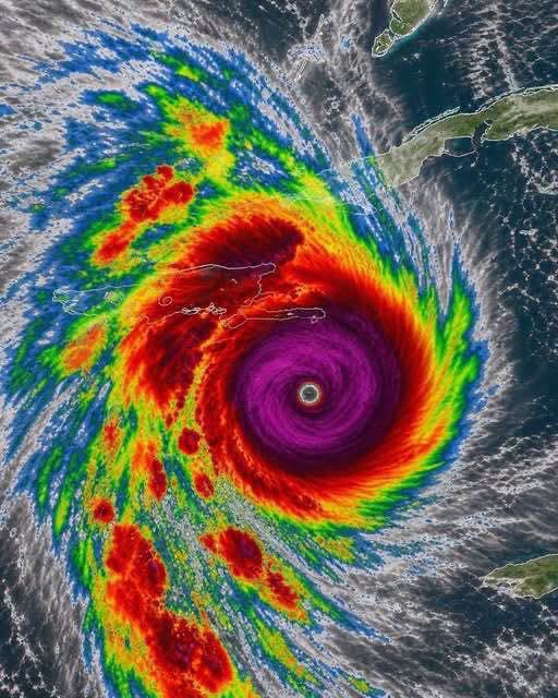
A dramatic satellite-style image showing a powerful hurricane with a clearly defined eye has been circulating online alongside claims that “Category 5 Hurricane Melissa is forming.” The image has attracted attention because of the storm’s intense colors and its enormous spiral of clouds.
However, the headline needs important context. Hurricane Melissa was a real and devastating Category 5 hurricane in October 2025, but the viral claim that it is forming now is not supported by current official information.
Understanding the storm’s history helps distinguish genuine hurricane information from outdated or misleading social media posts.
Was Hurricane Melissa a Real Category 5 Hurricane?
Yes. Hurricane Melissa became an extremely powerful Atlantic hurricane in October 2025. It strengthened over the Caribbean and reached Category 5 intensity before making landfall in Jamaica on October 28, 2025.
The storm brought catastrophic winds, torrential rainfall, flooding, and storm surge. Its impacts were particularly severe in Jamaica, where communities faced extensive damage to homes, infrastructure, roads, and essential services.
Melissa subsequently affected other parts of the Caribbean, including Cuba and the Bahamas. The storm became one of the most significant Atlantic hurricane events of 2025.
What Does Category 5 Mean?
The Saffir-Simpson Hurricane Wind Scale classifies hurricanes into five categories based on their maximum sustained winds.
A Category 5 hurricane has maximum sustained winds of at least 157 miles per hour, or approximately 252 kilometers per hour.
Storms of this intensity can cause catastrophic damage, including the destruction of many buildings, widespread infrastructure failures, and prolonged interruptions to electricity, communications, and water services.
However, the category describes wind speed rather than the full range of a hurricane’s dangers. Flooding, storm surge, and rainfall can also cause serious damage and loss of life.
What Does the Satellite Image Show?
The image depicts a large tropical cyclone with a well-defined eye surrounded by intense bands of clouds.
In a typical hurricane satellite image, the eye appears as a relatively calm central area, while powerful thunderstorms circulate around it. The surrounding cloud bands can extend hundreds of kilometers from the storm’s center.
The colors in enhanced satellite imagery often represent different cloud-top temperatures or other meteorological measurements, depending on the imaging product. They should not automatically be interpreted as a direct measurement of wind speed.
The image’s exact date and original source cannot be established from the picture alone, so it should not be treated as a live satellite image without verification.
Is Hurricane Melissa Forming Again in 2026?
The viral caption is misleading if it suggests that the same storm is currently forming again.
According to the U.S. National Hurricane Center’s update dated October 16, 2026, there were no active tropical cyclones in the Atlantic basin at that time.
Hurricanes are named when they develop during a particular season. Once a storm has dissipated, the same storm does not simply reform under its old name as a new hurricane. A future storm may develop in the Atlantic, but it would be a separate weather system.
For this reason, the claim that a new Category 5 Hurricane Melissa is currently forming should not be shared as breaking news without fresh confirmation from official meteorological authorities.
Why Do Old Hurricane Images Circulate Again?
Images of major storms can resurface long after the original event. Sometimes they are shared as historical reminders; in other cases, an old image is paired with a new or misleading caption that makes it appear current.
Dramatic satellite imagery can attract attention quickly, particularly when it is accompanied by urgent phrases such as “breaking news” or “Category 5.”
Before sharing a hurricane warning, check the publication date, the storm’s reported location, and the latest advisories from an official weather agency. This is especially important when a post does not identify the source or date of its image.
How to Stay Safe During a Real Hurricane Warning
If you live in or are traveling to an area threatened by a hurricane, follow the instructions issued by local emergency authorities.
Useful precautions include:
Monitoring official weather forecasts and emergency alerts.
Preparing drinking water, essential medicines, food, flashlights, and batteries.
Securing loose outdoor objects before dangerous winds arrive, when it is safe to do so.
Keeping important documents and essential supplies accessible.
Following evacuation instructions promptly.
Staying away from floodwater and avoiding unnecessary travel during dangerous conditions.
Never rely on a viral image alone to decide whether a storm is approaching your area.
Final Thoughts
Hurricane Melissa was a real Category 5 storm that caused severe damage in the Caribbean in October 2025. However, the viral claim that Category 5 Hurricane Melissa is forming now is not supported by the official Atlantic storm update available for October 16, 2026.
The image may be dramatic, but its appearance does not establish that it represents a current storm.
When it comes to hurricanes, accurate dates, verified forecasts, and official warnings are far more important than sensational social media captions. Checking the latest information before sharing can help prevent confusion and ensure that people receive reliable weather updates.