Hurricane Melissa: The Viral Category 5 Satellite Image and the Facts Behind It
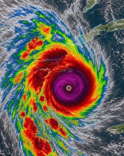
A dramatic satellite image showing a powerful hurricane with a clearly defined eye has been circulating online alongside the caption, “Breaking News: Large Category 5 Hurricane Melissa is forming.”
The image is striking, but the caption is misleading. Hurricane Melissa was a real and exceptionally powerful storm in October 2025. It is not currently forming as a new hurricane in October 2026.
According to the U.S. National Hurricane Center (NHC), there are currently no tropical cyclones in the Atlantic basin as of October 19, 2026. <Cite refs={[“turn184101search0″,”turn184101search9”]}/>
What Happened to Hurricane Melissa?
Hurricane Melissa developed in the Caribbean Sea in October 2025 and rapidly intensified into a Category 5 hurricane. It became one of the most powerful Atlantic hurricanes to make landfall in recorded history.
On October 28, 2025, Melissa struck southwestern Jamaica with estimated maximum sustained winds of approximately 185 mph (295 km/h). Its slow movement also produced destructive rainfall and severe flooding across parts of the Caribbean.
The storm caused catastrophic damage, particularly in Jamaica, and affected other islands in the Greater Antilles. The National Hurricane Center subsequently published a detailed report documenting the storm’s development, intensity, and impacts. <Cite refs={[“turn184101search15″,”turn184101search16”]}/>
What Does the Satellite Image Show?
The image displays several features associated with a powerful tropical cyclone:
The eye: The relatively calm central region of a mature hurricane.
The eyewall: The ring of intense thunderstorms surrounding the eye, where the strongest winds are typically found.
Spiral rainbands: Curved bands of clouds and thunderstorms extending outward from the center.
Color-enhanced cloud tops: Satellite imagery often uses colors to represent cloud-top temperatures and highlight areas of deep convection.
However, a satellite image alone cannot confirm a storm’s current category. Meteorologists combine satellite observations with aircraft measurements, surface observations, atmospheric data, and other tools to estimate a hurricane’s intensity.
The image also cannot independently establish when it was captured. It resembles the type of imagery used to depict a powerful hurricane, but its exact date and source cannot be verified from the picture alone.
What Does Category 5 Mean?
Category 5 is the highest category on the Saffir-Simpson Hurricane Wind Scale. It applies to hurricanes with sustained winds of at least 157 mph (252 km/h).
Such storms can cause catastrophic damage to buildings, infrastructure, trees, and electrical systems. Storm surge and flooding can also create life-threatening conditions, including far beyond the area directly beneath the eye.
A hurricane’s category describes its sustained wind intensity; it does not fully describe all its hazards or predict the damage at every location.
Why Is This Post Still Circulating?
Powerful hurricane images often continue circulating long after a storm has passed. A dramatic photograph paired with a “breaking news” caption can make an old event appear current.
Before sharing a hurricane alert, check the publication date and consult official weather agencies. For Atlantic storms, the National Hurricane Center provides current tropical weather outlooks, storm advisories, and historical reports.
The Bottom Line
Hurricane Melissa was a real Category 5 hurricane that devastated parts of the Caribbean in October 2025. However, the claim that a new Category 5 Hurricane Melissa is forming in October 2026 is not supported by the current National Hurricane Center outlook.
The key distinction is between a genuine historical storm image and a current weather warning. Always verify the latest official forecast before treating a viral post as an emergency alert.