Hurricane Melissa Category 5? The Truth Behind the Viral Satellite Image
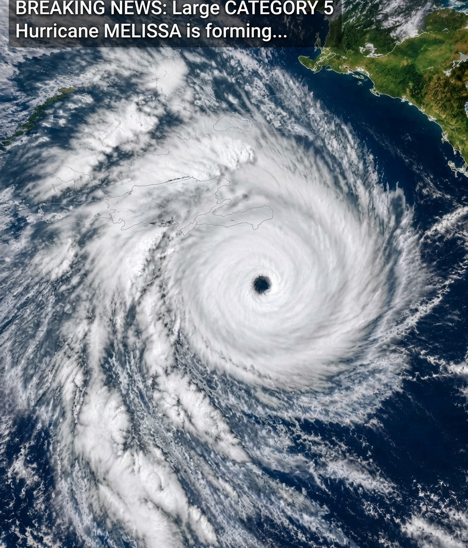
A dramatic satellite image showing a massive hurricane with a clearly defined eye is circulating online alongside claims that a “monster hurricane Melissa” is developing into a Category 5 storm. The image has caught people’s attention because of its striking colors and the enormous spiral of clouds surrounding the storm’s center.
But what does the image actually show? Is it a new weather emergency, an old satellite image, or a misleading social media post?
Before sharing a dramatic weather headline, it is important to separate verified information from speculation.
What Does the Satellite Image Show?
The photograph appears to show a powerful tropical cyclone with a well-defined eye surrounded by intense thunderstorms and spiraling cloud bands.
Satellite images help meteorologists examine a storm’s structure, estimate its intensity, and monitor changes in its organization. A clearly defined eye surrounded by strong thunderstorms can be a sign of an intense hurricane.
The bright colors in enhanced satellite images represent differences in cloud-top temperatures and other atmospheric properties, depending on the satellite product. They do not directly show wind speed or the official hurricane category.
Although the image looks dramatic, it cannot establish the storm’s identity, the date it was captured, or its current intensity without additional information.
Was Hurricane Melissa Really a Category 5 Hurricane?
Yes. Hurricane Melissa reached Category 5 intensity in the Atlantic during October 2025. It became one of the most powerful hurricanes of that season and caused catastrophic impacts in parts of the Caribbean, particularly Jamaica.
However, the historical existence of a Category 5 Hurricane Melissa does not mean that a new storm with the same name is currently developing.
The viral caption does not provide enough information to establish that the image represents a current event. The image should therefore not be presented as proof that a new Category 5 hurricane is forming.
What Does Category 5 Mean?
The Saffir-Simpson Hurricane Wind Scale classifies hurricanes according to their maximum sustained winds.
A Category 5 hurricane has maximum sustained winds of at least 157 mph (252 km/h).
Storms at this intensity can cause catastrophic damage to buildings, infrastructure, trees, and power systems. Dangerous storm surge and flooding can also threaten coastal communities.
Importantly, the category describes wind intensity. It does not fully measure the danger from rainfall, flooding, storm surge, or the size of the storm.
Why Can Powerful Hurricanes Be So Dangerous?
Hurricanes can create several life-threatening hazards, even when their winds are below Category 5 intensity.
Destructive Winds
Powerful winds can damage roofs, destroy poorly constructed buildings, topple trees, and bring down power lines. Flying debris can also cause serious injuries.
Storm Surge
Storm surge occurs when hurricane winds push seawater toward the coast. It can flood coastal neighborhoods, roads, and other low-lying areas, sometimes before the strongest winds arrive.
Heavy Rainfall and Flooding
Tropical cyclones can produce enormous amounts of rain. Flash floods and river flooding may occur far inland, even after a storm weakens or moves away from the coast.
Dangerous Ocean Conditions
Large waves and powerful currents can make beaches, harbors, and coastal waters extremely dangerous. Conditions can remain hazardous even when the storm’s center is far away.
How Can You Check Whether a Hurricane Warning Is Real?
When a dramatic hurricane post appears on social media, take a moment to verify the information.
1. Check the storm’s official name and location. A trustworthy weather report should identify where the storm is and when the information was issued.
2. Look for an official advisory. For Atlantic and eastern Pacific hurricanes, consult the U.S. National Hurricane Center.
3. Check the publication date. Old satellite images are frequently reshared without their original dates or captions.
4. Read the actual forecast. Look for official information about maximum sustained winds, the forecast track, watches, warnings, and expected impacts.
5. Avoid sharing unverified emergency claims. Incorrect hurricane reports can create unnecessary panic and distract people from genuine weather warnings.
Where Can You Find Reliable Hurricane Updates?
For current information about Atlantic hurricanes, visit the National Hurricane Center at:
https://www.nhc.noaa.gov
For weather warnings and official emergency instructions in other countries, consult the relevant national meteorological service and local emergency authorities.
If you live in an area under an official hurricane warning, follow local instructions promptly. Do not wait for a storm to reach its strongest intensity before taking protective action.
Final Thoughts
The satellite image circulating online is striking, but an image alone cannot confirm that a new Category 5 Hurricane Melissa is developing.
Hurricane Melissa was a real and devastating storm in 2025. Any claim that it is happening again must be checked against current official weather information rather than accepted from a viral caption.
In severe weather situations, accurate information can save lives. Always verify the date, storm identity, and official warnings before sharing dramatic claims.
Have you seen this hurricane image circulating on social media? Share your thoughts in the comments, and remember to check official weather updates before believing or sharing breaking-news posts.